Mountain Walks Scafell Pike

15 routes to enjoy on and around the Sca Fell range

Series title: Mountain Walks

Pre-order now for delivery in mid April
Stock due in early April

Pickup available at Omega Court, 352 Cemetery Rd, Sharrow,

Usually ready in 24 hours

Available to pre-order now

Pre-order to be in with a chance of winning a National Navigation Award Scheme course for two people*

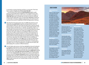
Mountain Walks Scafell Pike by Graham Uney is a guide to walking routes on and around the Sca Fell range in the Lake District. Among the 15 routes are classics like the Corridor Route and summit walks from Langdale and Eskdale, as well as the Esk Gorge and the Mosedale Horseshoe. Includes Ordnance Survey maps and downloadable GPX files.

Graham Uney Mountaineering logo

*All customers who pre-order Mountain Walks Scafell Pike from www.adventurebooks.com before the publication date of 1 May 2025 will be automatically entered into a prize draw to win a National Navigation Award Scheme course for two people worth over £300 courtesy of Graham Uney Mountaineering. The winner will be able to choose between a Bronze or Silver-level course depending on their experience. The two-day courses are run in the eastern Lake District. The winner will be chosen at random on 1 May and notified by email. 

Mountain Walks Scafell Pike by Graham Uney is a guide to walking routes to the summit of Scafell Pike – England’s highest mountain – in the Lake District. Alongside the summit routes, there are also lower-level alternatives for mixed weather or shorter days and those new to mountain walking.

Written by an experienced local mountain guide, the 15 inspiring routes include an ascent of Scafell Pike from Borrowdale via the Corridor Route, and the Mosedale Horseshoe across the valley, and even those who are familiar with the area will find new and imaginative route ideas to discover. Whether you aspire to climb Scafell Pike from Wasdale Head or you’re looking for an alternative adventure, this is the only guidebook you need.

Together with stunning photography, each route features: Ordnance Survey 1:25,000 maps; easy-to-follow, detailed directions; essential info about public transport and safety advice; details about the terrain and navigation; facilities, refreshments and points of interest; and downloadable GPX files.

  • FREE standard UK shipping
  • Sign up to our newsletter for 25% off
  • Secure checkout

Customer Reviews

Be the first to write a review
0%
(0)
0%
(0)
0%
(0)
0%
(0)
0%
(0)